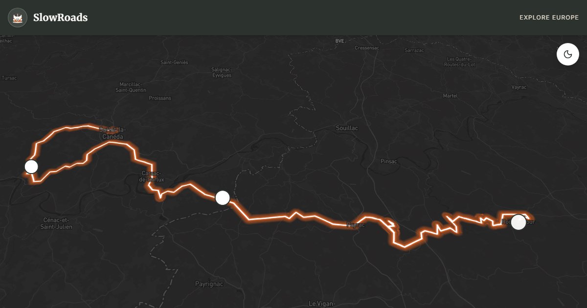
About This Route
Sarlat-la-Canéda to Rocamadour through the Périgord Noir: river castles at Beynac and Castelnaud, cliff village La Roque-Gageac, and a vertical pilgrimage town above the Alzou. Gentle valley D-roads suit classic campervans; park below cliff villages and walk — do not force a loaded camper into medieval cores. Allow 3–4 days for markets, canoe put-ins and foie gras country without rushing. Overnight on aires and campgrounds along the Dordogne; July–August fill fast. May and September bring softer light on honey-stone façades and quieter château car parks.
Detailed Route Guide
The Dordogne valley from Sarlat-la-Canéda to Rocamadour covers eighty kilometres through the Périgord Noir — a landscape of medieval market towns, river castles, prehistoric cave art, and restaurants where foie gras and confit de canard are daily currency rather than special-occasion luxuries. The driving follows D-roads along the river between cliff villages where honey-coloured stone catches the oblique light that makes this valley one of the most photographed in France. Gradients are gentle compared to mountain routes — a classic campervan handles the river roads comfortably — but medieval town centres at Sarlat, Beynac, and La Roque-Gageac require peripheral parking and a willingness to walk uphill through lanes built before the automobile existed.
Sarlat-la-Canéda anchors the northern end with one of the best-preserved medieval cores in France: golden limestone facades, a Saturday market spilling through narrow streets, and the scent of walnuts and truffles from shop doorways. The D703 downstream passes Beynac-et-Cazenac, where a cliff-top fortress overlooks the river, and Castelnaud-la-Chapelle on the opposite bank — two castles that faced each other across the Dordogne during the Hundred Years' War and now compete for visitors with falconry displays and medieval weapon collections. La Roque-Gageac clings to an east-facing cliff above the water, its single-file main street barely wide enough for a delivery van let alone a campervan — park below and walk up.
Rocamadour at the route's end is a vertical pilgrimage town: a staircase of two hundred and sixteen steps climbs from the lower town to a chapel where the Black Madonna has drawn pilgrims since the Middle Ages, and the cliff-side buildings appear to cascade rather than be built. Prehistoric sites — Lascaux IV replica near Montignac, Gouffre de Padirac chasm — sit within detour distance and require advance booking in summer. Allow two days minimum: Sarlat and the river castles on day one, Rocamadour and a gabare river boat trip from Beynac on day two. Domme, on its cliff above the river, adds another belvedere if you have a third morning.
Park campervans at Sarlat's outskirts aire and campgrounds — never inside the medieval centre. Beynac and La Roque-Gageac have day car parks below the cliff villages without overnight permission. Rocamadour's L'Hospitalet motorhome area fills by 10am in July — arrive early or use plateau campgrounds. September and October bring golden river light, truffle markets in Sarlat, and quieter castle viewpoints; May and June offer green riverbanks before the summer crush. Winter is peaceful but cliff-village restaurants may close from November, and morning fog along the river is common. Keep the van on the valley floor roads; save cliff-top approaches for short, unladen scouting walks when unsure about turning space.
Food is part of the driving rhythm here: stop for a walnut cake or a glass of Bergerac wine at a riverside terrace rather than rushing the next castle ticket. In high summer, start château visits at opening time and keep afternoons for swimming spots or shaded aires — limestone cliffs radiate heat, and a dark-coloured older van parked in full sun becomes an oven. That pacing is the whole point of SlowRoads in the Périgord.
Frequently Asked Questions
Points of Interest
Beynac Castle
Castle
Cliff fortress above the Dordogne
La Roque-Gageac
Town
Cliff village on the river
Rocamadour
Monument
Pilgrimage village on cliff
Route Highlights
Route Information
Navigation
* Supported by HERE Technologies, headquartered in Amsterdam, Europe. Precise routing through all waypoints.
* Waze only navigates to the starting point. Use Google Maps for the full scenic route.
Offline GPS Navigation
Download the GPX route file to navigate offline using your favorite GPS device or app (Garmin, TomTom, OsmAnd, Gaia GPS).
Ask Copilot (AI Travel Guide)
Hello! I am your SlowRoads Copilot. I know the Dordogne Valley & Castles intimately. Ask me about scenic viewpoints, local history, hidden culinary gems, or the best camper spots along the way!