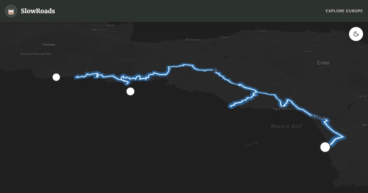
About This Route
Follow Crete’s Libyan Sea coast from Matala to Hora Sfakion — about 130 km of cliff caves, Preveli palms, and steep Sfakia roads for patient classic campervans. Short sharp climbs and polished asphalt demand sound brakes, tyres, and cooling in older low-power vans. Matala’s hippie caves and Preveli beach walks reward stops; Loutro is boat-only — leave the van in Hora Sfakion. Organised campsites only; gorge trailheads enforce no overnighting. April–June and September–October beat July heat. Fill fuel before quieter Sfakia stretches and expect goats more often than coaches off the August strip.
Detailed Route Guide
Ninety-five kilometres from Matala to Hora Sfakion trace Crete's Libyan Sea coast — a road carved into limestone cliffs where the White Mountains drop to turquoise water and every bend reveals a cove that feels discovered rather than marketed. This is steep, exposed driving: the road west of Frangokastello climbs and falls in second-gear gradients that test an older campervan's cooling and brakes, especially after the midday sun heats the engine on sustained ascents toward Anopolis. Allow two days minimum — one for Matala's cliff caves and the Mesara plain, one for the Sfakia section where Samaria Gorge empties into the sea and the village of Chora Sfakion waits at the harbour.
Matala opens the route with its famous Roman-era caves carved into sandstone cliffs above a beach that once hosted a hippie colony — today it is a mellow swimming stop before the climb inland toward the Messara wine country. Frangokastello brings a Venetian fortress above a shallow bay where locals claim ghost soldiers march at dawn in May — whether you believe the Drosoulites legend or not, the beach below is ideal for a campervan lunch stop with the van parked in the signed lot, not on sand. The Samaria Gorge trailhead at Xyloskalo sits above the gorge on the northern flank; even if you are not hiking the full sixteen-kilometre descent, the viewpoints above the gorge rim justify a detour on clear mornings.
Chora Sfakion (Sfakia) anchors the route's end — a harbour village where ferry boats connect to Loutro, Agia Roumeli, and other car-free settlements along the coast. Sfakian pie (sfakianopita), thin cheese pastries drenched in honey, appears in every taverna, and the waterfront promenade fills with hikers finishing the gorge walk. The road between Anopolis and Imbros passes through hamlets where sheep block the tarmac and stone shepherds' huts dot the slopes — drive slowly, use horn sparingly, and never attempt to pass on blind cliff bends.
Campervan parking in Matala uses the municipal lot above the beach; overnight stays are tolerated in shoulder season but check current signage. Sfakia has limited flat space — the harbour car park suits day visits; consider camping at Frangokastello or Vrisses inland if you need hook-ups. Fuel and groceries are sparse after Matala until Sfakia; fill in Mires or Vrisses before the coastal section. May and June offer wildflowers and gorge hiking before July heat; September is ideal for empty beaches and calm Libyan Sea swimming. Winter closes the Samaria Gorge and can bring landslides on cliff sections — check Crete road authority alerts before committing to the full coastal drive.
Practical notes for classic campervans: the coastal and gorge-approach roads are asphalt but exposed, with polished surfaces that get slippery in sudden Libyan Sea showers. Use engine braking on the Imbros and Anopolis descents; do not ride the foot brake for long cliff sections. Preveli palm beach is reached by a steep access road and a walk — park only in signed lots, not on soft sand. Loutro has no road access; leave the van in Hora Sfakion and take the passenger boat. Organised camping around Plakias and Frangokastello is the reliable overnight option when harbour parking is full. Check Samaria Gorge opening dates if you plan the Xyloskalo viewpoint detour — the trail closes in winter and after heavy rain. Allow buffer time for ferry or boat connections if you continue west toward Paleochora.
Frequently Asked Questions
Points of Interest
Matala Caves
Nature
Hippie-era cliff caves
Preveli Palm Beach
Nature
Palm grove river mouth beach
Loutro
Town
Car-free harbour village
Route Highlights
Route Information
Navigation
* Supported by HERE Technologies, headquartered in Amsterdam, Europe. Precise routing through all waypoints.
* Waze only navigates to the starting point. Use Google Maps for the full scenic route.
Offline GPS Navigation
Download the GPX route file to navigate offline using your favorite GPS device or app (Garmin, TomTom, OsmAnd, Gaia GPS).