About This Route
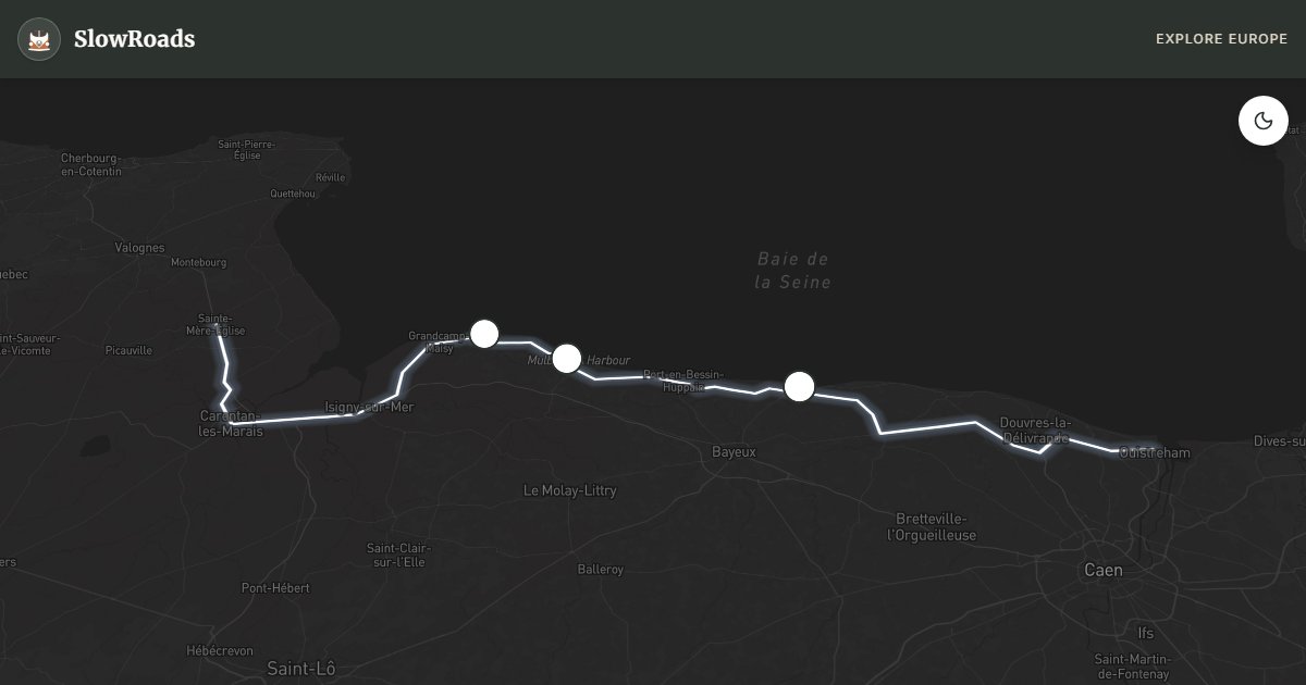
Drive Normandy's D-Day coast from Ouistreham to Sainte-Mère-Église: Sword to Utah beaches, Arromanches Mulberry ruins, Omaha, the American Cemetery and Pointe du Hoc. Flat coastal D-roads suit classic campervans; allow 2–3 days and use campgrounds near Bayeux. Deeply moving history with gentle driving — no steep passes, generous site parking outside high season. Late May–June bring commemorations and green bluffs; September offers quieter roads and golden light. Free outdoor memorials; museums charge modest entry — arrive early at Omaha and the cemetery in summer.
Detailed Route Guide
Few drives in Europe carry the emotional weight of the Normandy D-Day Coast. Stretching roughly 99 kilometres along the Calvados shoreline from Ouistreham to Sainte-Mère-Église, this coastal route passes through the very beaches where, on the morning of 6 June 1944, the largest seaborne invasion in history began. For slow travellers arriving in a classic van, this is not merely a scenic drive but a pilgrimage through one of the most consequential stretches of land in the modern world.
The route begins in Ouistreham, the port town at the eastern end of Sword Beach, where British and French commandos landed in the pre-dawn darkness. From here the road threads westward through Colleville-Montgomery (named after the British field marshal), past Courseulles-sur-Mer on Juno Beach — the Canadian sector — and on to Arromanches-les-Bains, where the remains of the artificial Mulberry Harbour are still clearly visible from the shore. These prefabricated concrete caissons, towed across the Channel after D-Day, allowed 2.5 million men, 500,000 vehicles, and 4 million tonnes of supplies to be landed in the weeks following the invasion. Standing on the beach at Arromanches and watching the rusted hulks projecting from the sea is genuinely humbling. The nearby Musée du Débarquement is one of the best D-Day museums on the route, with original maps, photographs, and a scale model of the harbour.
Continuing west, the road reaches Omaha Beach — the bloodiest sector of the entire landing, where American forces of the 1st and 29th Infantry Divisions suffered catastrophic losses against heavily fortified German positions on the bluffs above. The beach today is vast and peaceful, with soft sand stretching in both directions. The American Military Cemetery at Colleville-sur-Mer sits on the bluff directly above Omaha, its roughly 9,389 white marble headstones arranged in perfect rows across about 172 acres of manicured lawn. This is the most visited American cemetery in Europe, and even on a busy summer day it retains a profound solemnity. Beyond Omaha, the route reaches Pointe du Hoc, where US Army Rangers scaled 30-metre cliffs under fire to neutralise a German gun battery. The bomb-cratered plateau, with its original German bunkers still intact, is the most evocative physical landscape along the entire route. Finally, the road ends in Sainte-Mère-Église, the first French town to be liberated — made famous by paratrooper John Steele, whose parachute caught on the church steeple during the night drop.
For classic campervan travellers, the D-Day coast is one of the most van-friendly routes in France. The entire stretch follows well-maintained coastal roads (D514 and connecting routes) that are entirely flat. There are no steep sections, no tight mountain passes, and no height restrictions on the main route. Parking at the major sites (Omaha, Arromanches, Pointe du Hoc, the American Cemetery) is ample and generally free outside high season. The Normandy region is well served by campgrounds, particularly around Bayeux — a gorgeous medieval city with its famous tapestry, just 10 kilometres inland — and around Grandcamp-Maisy near Pointe du Hoc. The best season is May and June: the weather is mild, the grass is green, and the commemorations around 6 June bring the history vividly to life with ceremonies, veterans, and re-enactors. July and August bring the largest crowds but the longest days. September and October offer quiet roads and golden coastal light.
Frequently Asked Questions
Points of Interest
Omaha Beach Memorial
Monument
Mulberry Harbour Ruins
Monument
Pointe du Hoc
Monument
Route Highlights
Route Information
Navigation
* Supported by HERE Technologies, headquartered in Amsterdam, Europe. Precise routing through all waypoints.
* Waze only navigates to the starting point. Use Google Maps for the full scenic route.
Offline GPS Navigation
Download the GPX route file to navigate offline using your favorite GPS device or app (Garmin, TomTom, OsmAnd, Gaia GPS).
Ask Copilot (AI Travel Guide)
Hello! I am your SlowRoads Copilot. I know the Normandy D-Day Coast intimately. Ask me about scenic viewpoints, local history, hidden culinary gems, or the best camper spots along the way!