About This Route
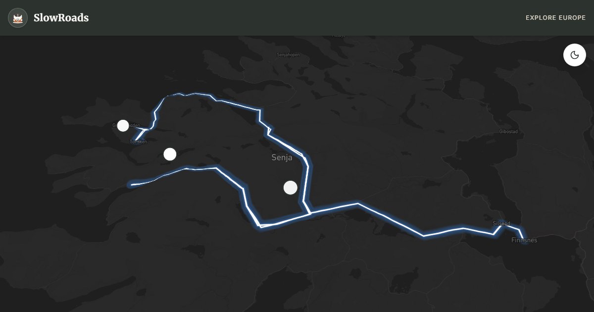
Norwegian Scenic Route Senja (Fv86/862) links Botnhamn to Gryllefjord via Tungeneset, Husøy, and Arctic fjord passes. Steep, windy island driving for classic and low-power campervans — fuel in Finnsnes, check winter closures, and allow two slow days. Camps are limited; plan overnight stops. Tungeneset's wave-lashed rocks are the postcard stop. A wilder Arctic sibling to Lofoten with fewer coaches and more empty pullouts when weather cooperates. Ferry and weather windows shape the itinerary. Allow extra time for photo pullouts, fuel stops, and cooling breaks in older vans.
Detailed Route Guide
About 134 kilometres on Senja — Norway's second-largest island after Hinnøya (excluding Svalbard), north of the Lofoten arc — follow Norwegian Scenic Route Senja (Fv86 / Fv862) from Botnhamn to Gryllefjord, with signed detours to Husøy and Mefjordvær, through Arctic fjords, fishing hamlets, and mountain passes that Norwegian tourism boards call "Norway in miniature" without exaggeration. Reach the island via Gisund Bridge at Finnsnes or the Botnhamn–Brensholmen ferry toward Tromsø. This is steep, exposed driving: switchbacks climb from sea level to ridge viewpoints where reindeer graze above cloud inversions, and a loaded classic camper demands second gear on ascents, engine braking on descents, and honest assessment of wind, ice, and fog before committing to the highest sections. Allow two days minimum; rushing Senja defeats the island's rhythm of tide, weather, and light that shifts from steel-grey to gold within a single hour.
Tungeneset delivers the route's architectural highlight — a viewpoint platform cantilevered over Bergsfjord where angular steel frames mountains and water in compositions that photographers chase through midnight sun in June and aurora displays from September to March. Husøy, linked by a causeway, is a working fishing village of coloured warehouses and drying racks where cod still arrives by boat and the bridge parking fills with tripods at sunset. Bergsbotn and other signed pullouts along Fv862 offer quieter fjord perspectives when Tungeneset is crowded. Gryllefjord at the route's western end is an Arctic harbour where boats tie up beneath cliffs; in summer a ferry links Gryllefjord to Andenes on Andøya, connecting Senja to another National Tourist Route for travellers continuing north.
Campervan crews should fuel in Finnsnes before the island circuit — pumps at Gryllefjord are seasonal and distances between services feel longer in fog. Finnsnes Stellplats offers services; Gryllefjord harbour parking may tolerate quiet overnights with harbour-master courtesy where signs allow. Tent camping under allemannsretten is allowed at least 150 metres from dwellings on uncultivated land; campervans may overnight only where parking is legal — never off-road on fragile Arctic turf or beaches. Route sections may close in winter storms — check Statens vegvesen (vegvesen.no) before departure and carry winter tyres when required. Husøy bridge parking is day-visit only. No road tolls on the scenic route; Gisund Bridge is free. Crosswinds on exposed ridges can push high-sided vans — reduce speed and use pullouts rather than fighting the gusts.
Midnight sun from late May through July keeps Tungeneset busy until 1am without darkness — arrive late to avoid coach convoys, or visit at dawn when the platforms are empty. September to March brings aurora potential over Gryllefjord when skies clear, though daylight hours shrink fast. Winter driving requires approved winter tyres and willingness to turn back if vegvesen.no reports closure on the Bergsbotn section. Shoulder months — June and early September — balance open roads, manageable traffic, and extraordinary Arctic light. Two days covers Tungeneset, Husøy, and Gryllefjord at a classic-camper pace; add a third for weather waits, a second aurora attempt, or the summer ferry link toward Andøya.
Frequently Asked Questions
Points of Interest
Tungeneset
Nature
Cantilevered steel viewpoint over Bergsfjord — signature stop of Scenic Route Senja.
Husøy
Town
Working fishing village on a causeway island; bridge parking is for day visits only.
Gryllefjord
Town
Arctic fishing harbour; summer ferry to Andenes
Route Highlights
Route Information
Navigation
* Supported by HERE Technologies, headquartered in Amsterdam, Europe. Precise routing through all waypoints.
* Waze only navigates to the starting point. Use Google Maps for the full scenic route.
Offline GPS Navigation
Download the GPX route file to navigate offline using your favorite GPS device or app (Garmin, TomTom, OsmAnd, Gaia GPS).
Ask Copilot (AI Travel Guide)
Hello! I am your SlowRoads Copilot. I know the Senja National Tourist Route intimately. Ask me about scenic viewpoints, local history, hidden culinary gems, or the best camper spots along the way!