About This Route
Stanage Edge to Monsal Dale — gritstone escarpments, limestone dales, and the best of Derbyshire.
Detailed Route Guide
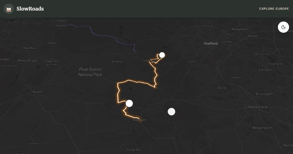
Forty kilometres from Hathersage to Bakewell link the gritstone edges and limestone dales that define Britain's first national park — a compact day's drive where Dark Peak moorland drops suddenly into White Peak valleys stitched together by dry-stone walls and stone-built villages. The A6187 from Hathersage climbs toward Stanage Edge, a four-mile escarpment of coarse gritstone that has shaped British climbing since the Victorian era, with boulders scattered below like a natural gymnasium. From there, lanes and the B6001 descend through Hope Valley toward Monsal Dale, where a disused railway viaduct spans the River Wye, and onward to Bakewell, a market town synonymous with its almond-and-jam pudding sold in shop windows along the riverbank.
Stanage Edge rewards an early stop before coach parties arrive: walk the rim for views over Derwent Valley reservoirs and the distant silhouette of Kinder Scout, the highest point in the Peak District. Monsal Head viewpoint looks directly down on the Headstone Viaduct — the Monsal Trail now runs through its tunnels for cyclists and walkers, but the view from the car park remains the classic Derbyshire photograph, especially in morning mist. Chatsworth House, seat of the Duke of Devonshire, sits a short detour east with Capability Brown gardens, contemporary sculpture, and a farm shop that justifies its own hour. The driving between these points is gentle by Peak District standards — no Porlock-grade gradients — though Winnats Pass near Castleton can slick after rain when limestone weeps onto the road surface.
A VW T3 navigates gritstone lanes to Stanage and Monsal Head without strain, and the forty-kilometre total suits a single day's unhurried pace. Hathersage swimming pool car park serves day visitors with toilets and a village shop nearby; Bakewell showground camping handles overnighters during fair seasons; North Lees campsite beneath Stanage Edge books out in summer and puts you walking distance from the edge at dawn. Monsal Head car park closes overnight — plan to stay in Hathersage or Bakewell rather than the viewpoint itself, where there are no facilities and the lane is narrow for turning a campervan after dark.
Late spring fills the edges with bilberry and the dales with wildflowers while lambs occupy the walled fields below Stanage. September avoids peak-season coach traffic at Chatsworth while keeping clear walking weather on the Monsal Trail. Winter mist on Stanage Edge is atmospheric for photography but Winnats Pass can ice over without warning — check Derbyshire County Council gritting maps before an early start. One day covers Hathersage, Stanage, Monsal Dale, and Bakewell; add a second for Chatsworth gardens and the full Monsal Trail walk through the Headstone Viaduct tunnel. Stop for a genuine Bakewell pudding — not the iced supermarket version — at one of the old bakeries on Rutland Square before leaving town.
Frequently Asked Questions
Points of Interest
Stanage Edge
Nature
Four-mile gritstone escarpment
Monsal Head
Nature
View over Monsal Dale viaduct
Chatsworth House
Castle
Duke of Devonshire's stately home
Route Highlights
Route Information
* Waze only navigates to the starting point. Use Google Maps for the full scenic route.