About This Route
Scenic Route Hardangervidda (Rv7) crosses Northern Europe's largest plateau from Haugastøl to Eidfjord past Vøringsfossen. Steady climbs, exposed weather, and a steep Måbødalen descent — open year-round with possible winter convoys. Classic and low-power campervans should fuel before the plateau, watch wind, and use engine braking on the descent. Pullouts for waterfall views fill in summer. A high, open Nasjonal Turistveg stage where weather, not hairpins, sets the difficulty. Carry layers even in July. Allow extra time for photo pullouts, fuel stops, and cooling breaks in older vans.
Detailed Route Guide
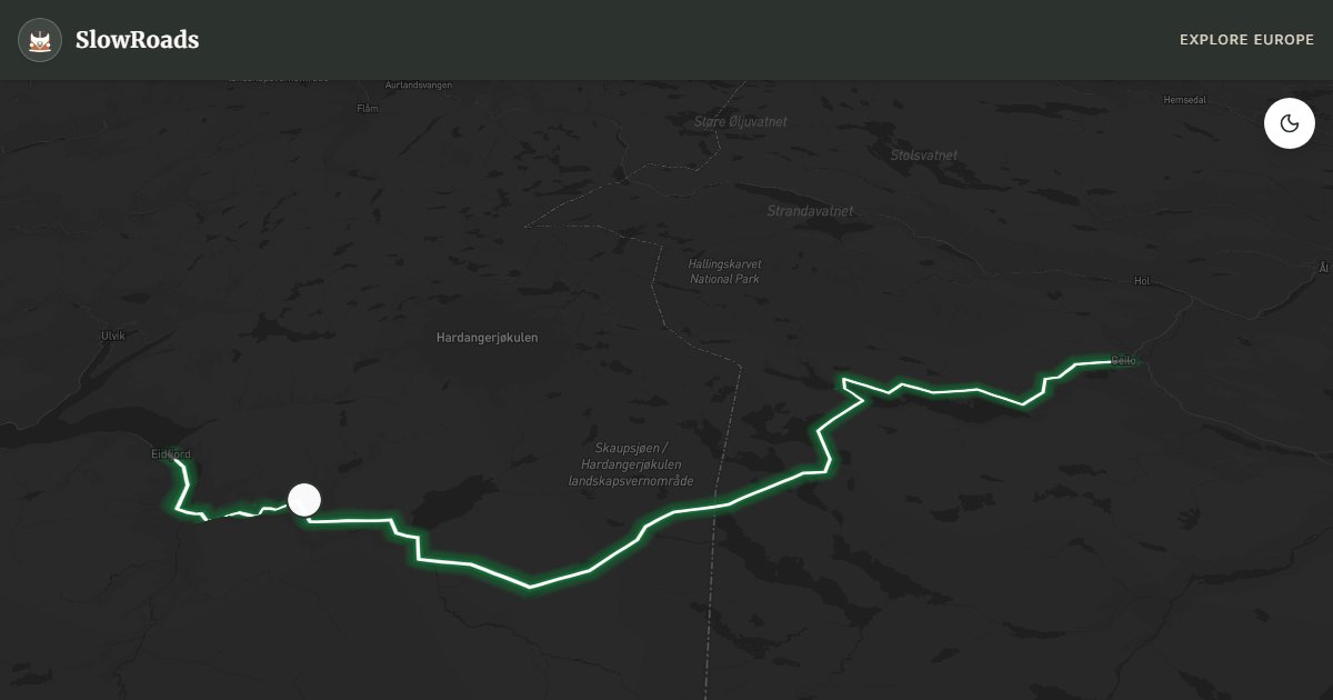
The Hardangervidda Plateau Drive on the Rv7 is one of Norway's most elemental road experiences — a crossing of the largest mountain plateau in Northern Europe, a vast treeless wilderness of lichen-covered rock, glacial lakes, and sub-Arctic sky that stretches for thousands of square kilometres. The Hardangervidda hosts Europe's largest wild reindeer population (historically often cited around 8,000–12,000 winter animals; recent counts have been lower, roughly 3,500–8,000 depending on year), and it is one of the few places in Europe where you might encounter them from the road on an ordinary day's drive. Official Norwegian Scenic Route Hardangervidda runs about 84 kilometres between Haugastøl and Eidfjord on Rv7; many travellers continue from Geilo to Haugastøl as an approach. The road threads high plateau, the dramatic Måbødalen descent, and Vøringsfossen — a sequence that feels more like crossing a country than driving a single scenic link.
The highlight that most visitors come specifically to see is Vøringsfossen — one of the most famous waterfalls in Norway, where the Bjoreio river drops 182 metres in a series of cascades into the Måbødalen gorge below. The viewpoints above the falls are genuinely spectacular, and the sheer scale of the drop — the water seems to fall into a void — is one of those natural features that photographs struggle to capture. Below Vøringsfossen, the modern Rv7 descent into Måbødalen uses tunnels opened in the 1980s; the older 1916 road through the valley remains as a heritage walking and cycling route. West of Eidfjord, the Hardanger Bridge (Rv13, opened 2013) is a separate fjord crossing — useful for onward travel toward Odda or Bergen, but not part of the plateau scenic route itself. Apple orchards and turquoise Hardangerfjord water appear only after you leave the plateau behind.
For classic and low-power campervans, the Hardangervidda presents specific challenges and rewards in equal measure. The plateau section of the Rv7 is well-maintained but entirely exposed — wind, rain, and occasional summer snow squalls are all possible even in July, and the temperature at around 1,250 metres can be 10–15 degrees colder than at sea level. The gradients on the main plateau road are steady rather than savage, manageable for a classic or low-power camper in the appropriate gear. The descent to Eidfjord and the Hardangerfjord is steeper and requires careful engine braking through the tunnelled Måbødalen section. Carry warm layers, check coolant before the climb from either side, and plan fuel in Geilo or Eidfjord rather than assuming plateau pumps. Tent camping under allemannsretten is allowed on uncultivated land; campervans may overnight only where parking is legal — never drive off-road onto fragile plateau turf.
Unlike most Norwegian mountain passes, Rv7 over Hardangervidda is kept open year-round, though winter storms can force temporary closures or convoy driving behind snowploughs — always check vegvesen.no. Vøringsfossen viewpoints and the step bridge are typically closed in winter. Late June through August offers the most reliable plateau weather and extraordinary light; September brings autumn colour to the birch scrub on the plateau edges and quieter roads. The Hardangervidda Nature Centre in Eidfjord provides excellent context for the plateau landscape and reindeer ecology and is worth a visit before or after the crossing. Allow a full day if you want time at the falls, a walk on the old road, and a slow descent to the fjord without rushing a loaded camper through the tunnels.
Frequently Asked Questions
Points of Interest
Vøringsfossen Waterfall
Nature
One of Norway's most visited nature attractions. A spectacular 182m free-fall from the plateau into the Måbødalen valley.
Måbødalen Valley
Nature
Steep glacial valley with tunnels on Rv7; the old 1916 road is a heritage walking/cycling route. Hardanger Bridge (Rv13) lies west of Eidfjord, not on this plateau stretch.
Route Highlights
Route Information
Navigation
* Supported by HERE Technologies, headquartered in Amsterdam, Europe. Precise routing through all waypoints.
* Waze only navigates to the starting point. Use Google Maps for the full scenic route.
Offline GPS Navigation
Download the GPX route file to navigate offline using your favorite GPS device or app (Garmin, TomTom, OsmAnd, Gaia GPS).
Ask Copilot (AI Travel Guide)
Hello! I am your SlowRoads Copilot. I know the Hardangervidda Plateau Drive intimately. Ask me about scenic viewpoints, local history, hidden culinary gems, or the best camper spots along the way!