About This Route
Montenegro's southernmost strip — twelve kilometres of fine sand from Ulcinj's Velika Plaža to the Ada Bojana river delta where the Bojana meets the Adriatic. Flat coastal road, kite-surfing beaches, and a unique triangular island at the border with Albania. WARNING: The final road to Ada Bojana is unpaved and sandy — take care with two-wheel-drive vans after rain.
Detailed Route Guide
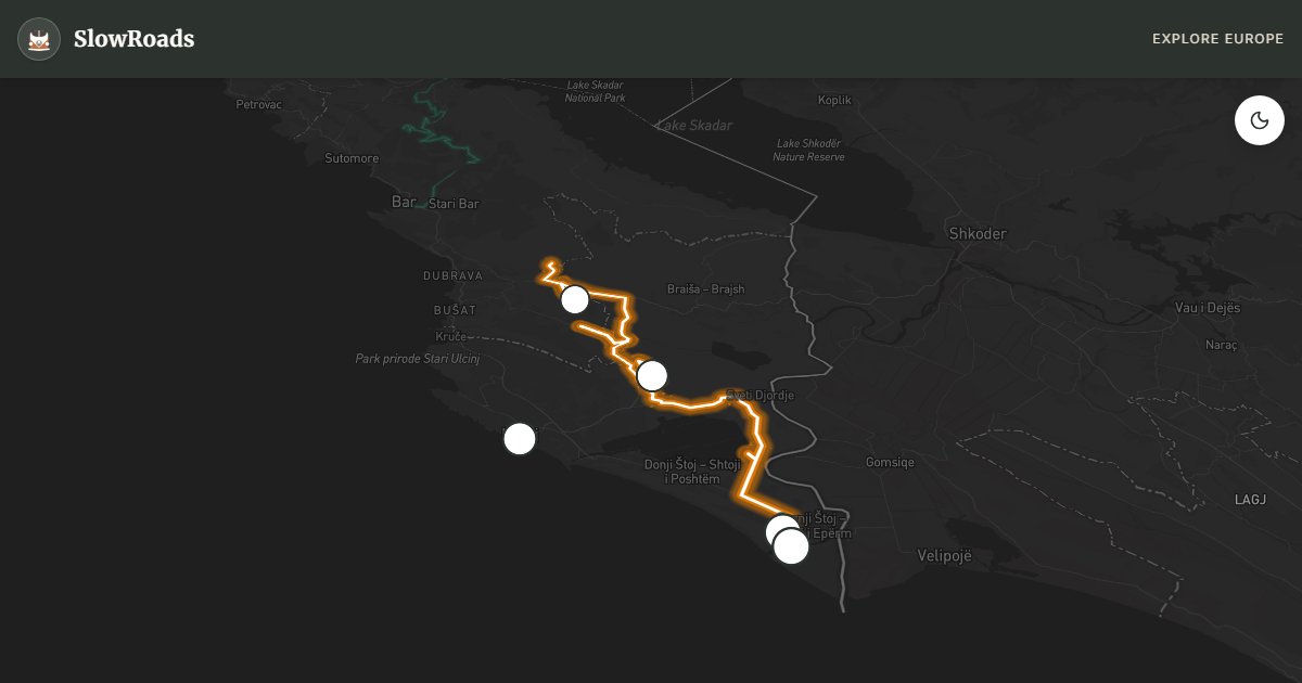
The Ada Bojana coast is where Montenegro runs out of country — the last sandy stretch before the Albanian border, where the Bojana River splits into channels and rejoins the Adriatic around a triangular island that has become one of the Adriatic's most distinctive destinations. The drive from Ulcinj to Ada Bojana, roughly thirty-five kilometres along the flat coastal plain, is the antithesis of Kotor's serpentines: wide horizons, warm wind, and a landscape of sand, olive groves, and wooden seafood shacks that feels closer to Greece than to the mountain-walled bay two hours north.
Ulcinj is the starting point — a town with a layered history reflected in its Ottoman old town (Stari Ulcinj) perched on a cliff above the port. The walled quarter of narrow lanes, mosques, and balconied stone houses is one of the best-preserved Islamic urban landscapes on the Adriatic, and its sunset views over the bay are exceptional. Below the old town, the modern resort strip begins, but the real draw is south: Velika Plaža — Long Beach — twelve kilometres of fine golden sand backed by dunes and pine scrub. This is Montenegro's longest beach and one of the premier kite-surfing locations in the Mediterranean, with steady thermal winds from May through September and several schools offering lessons and equipment rental.
The road south from Velika Plaža becomes progressively quieter and more rural. Olive groves — Ulcinj's other famous product, alongside the salt pans that have operated since Roman times — line the route. Valdanos Bay offers a pebble alternative to the sand, enclosed by ancient trees and popular with locals. As you approach the Bojana delta, the landscape opens: river channels, fishing boats, and the distinctive silhouette of Ada Bojana island — a three-sided delta formation created when the river was artificially diverted in the 19th century.
Ada Bojana itself is reached by a narrow, partially unpaved road that crosses the river by a small bridge. The island has a relaxed, slightly bohemian atmosphere: wooden cabin restaurants serving fresh carp and eel, nudist camping areas on the southern tip, and kite-surfing schools exploiting the consistent winds where river meets sea. The border with Albania is a few hundred metres away across the water — close enough to see farmers working fields on the other bank.
For slow van travellers, this route is mechanically trivial — entirely flat, no mountain challenges, and several campsites along Velika Plaža (including Safari Camp and autocamp options). The only caution is the final approach to Ada Bojana: after rain, the unpaved section can be soft sand that challenges heavy vans without momentum. Visit in late afternoon for the best light and fewer day-trippers from Podgorica. May, June, and September offer warm water, good wind, and manageable crowds; July and August are peak beach season.
Frequently Asked Questions
Points of Interest
Ulcinj Old Town
Monument
Ottoman-era walled town on a cliff above the port — mosques, narrow lanes, and sunset views.
Velika Plaža (Long Beach)
Nature
Twelve kilometres of uninterrupted sand — Montenegro's longest beach and a kite-surfing hotspot.
Ada Bojana Island
Nature
A triangular river island at the mouth of the Bojana — nudist camps, seafood restaurants, and kite schools.
Bojana River Mouth
Nature
Where the river divides Montenegro from Albania — calm water on one side, open sea on the other.
Valdanos Bay
Nature
A pebble cove surrounded by olive groves — quieter alternative to the main beach strip.
Route Highlights
Route Information
* Waze only navigates to the starting point. Use Google Maps for the full scenic route.
Ask Copilot (AI Travel Guide)
Hello! I am your SlowRoads Copilot. I know the Ada Bojana Coast intimately. Ask me about scenic viewpoints, local history, hidden culinary gems, or the best camper spots along the way!