About This Route
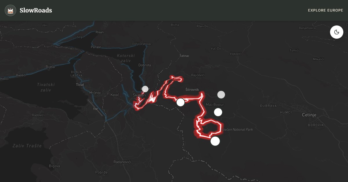
Legendary Njeguši road from Kotor's fortified bay to Lovćen National Park — roughly twenty-five numbered hairpins in limestone with Bay of Kotor views unfolding below. Grades of 8–10% on narrow switchbacks test brakes and cooling in classic and low-power campervans; summer coaches add pressure, so start before 9 AM. Pull into signed bays to cool, engine-brake the descent, and never force a pass on blind bends. Njeguši smoked ham and the Njegoš mausoleum reward the climb. Wild camping is officially not allowed — use bay-side campsites after the descent.
Detailed Route Guide
The road from Kotor to Njeguši — sometimes called the Old Cetinje Road or simply "the serpentine" — is Montenegro's most famous mountain drive and one of the most dramatic short climbs in the Balkans. Built in the late 19th century to connect the Adriatic port of Kotor with the old royal capital of Cetinje, it rises roughly 900 metres in just eight kilometres via twenty-five numbered hairpin bends carved directly into the limestone cliffs above the Bay of Kotor. From the first switchback above the old town walls, the view opens onto one of Europe's most extraordinary landscapes: a submerged river canyon filled with navy-blue water, ringed by mountains that drop almost vertically to the shore.
Driving the serpentine in a slow vintage van is an exercise in patience and cooling management. The gradient on the steepest sections reaches 8–10%, sustained over multiple consecutive hairpins where passing oncoming traffic — especially tour coaches in July and August — requires inching past on narrow stone-edged corners. The road surface is generally good asphalt, but the corners are tight and the drop on the outside edge is real. Classic and low-power campervan drivers should climb in first or second gear, stop at the numbered viewpoints to let the engine breathe, and avoid midday heat if possible. The descent is equally demanding on brakes; use engine braking throughout.
The village of Njeguši at the top of the climb is worth a deliberate stop. This highland hamlet produced the Petrović-Njegoš dynasty that shaped modern Montenegro, and its smokehouses still cure the country's most celebrated ham and cheese. From Njeguši, a continuation road leads to the Lovćen Mausoleum — Petar II Petrović-Njegoš's granite tomb perched at 1,657 metres with a 360-degree panorama that on clear days stretches from the Bay of Kotor to the Albanian Alps. Allow a full day: morning ascent before the coaches arrive, lunch in Njeguši, mausoleum visit, and a slow descent back to Kotor for an evening walk on the UNESCO-listed old town walls.
The serpentine is open year-round, though winter ice is possible above 600 metres. Spring (April–May) and autumn (September–October) offer the best balance of clear views and manageable traffic. Camping is available in Kotor's bay-side campsites; wild camping is officially not allowed in Montenegro — use bay-side campsites; the serpentine and Lovćen National Park are no exception. Combine this climb with the Bay of Kotor loop for a complete coastal-and-mountain Montenegro introduction — but tackle the serpentine on a fresh, cool morning before the heat and coaches arrive.
Combine the climb with a Cetinje or Lovćen Mausoleum extension only if the engine has cooled and the day still has light. Euro cash covers park fees and Njeguši pršut stops. Classic and low-power campervans that start before 9 AM avoid coach pressure on the numbered hairpins. Overnight only at legal campsites — wild camping is officially not allowed.
Numbered viewpoints are cool-down bays as much as photo stops — use them. Oncoming coaches own the tightest hairpins in August; yield early. Classic and low-power campervans that engine-brake the descent back to Kotor protect pads for Durmitor later in the trip.
Frequently Asked Questions
Points of Interest
Kotor Old Town Walls
Monument
UNESCO-listed Venetian fortress walls rising directly from the fjord-like bay.
Njeguši Viewpoint
Nature
Mid-serpentine pullout with the full sweep of the Bay of Kotor spread below.
Njeguši Village
Town
Birthplace of the Petrović dynasty, famous for smoked ham (njeguški pršut) and cheese.
Lovćen Mausoleum
Monument
Petar II Petrović-Njegoš entombed at 1,657 m with views to Albania on clear days.
Ivanova Korita
Nature
Mountain meadow and picnic area beneath the Lovćen summit ridge.
Route Highlights
Route Information
Navigation
* Supported by HERE Technologies, headquartered in Amsterdam, Europe. Precise routing through all waypoints.
* Waze only navigates to the starting point. Use Google Maps for the full scenic route.
Offline GPS Navigation
Download the GPX route file to navigate offline using your favorite GPS device or app (Garmin, TomTom, OsmAnd, Gaia GPS).
Ask Copilot (AI Travel Guide)
Hello! I am your SlowRoads Copilot. I know the Kotor–Lovćen Serpentine intimately. Ask me about scenic viewpoints, local history, hidden culinary gems, or the best camper spots along the way!