About This Route
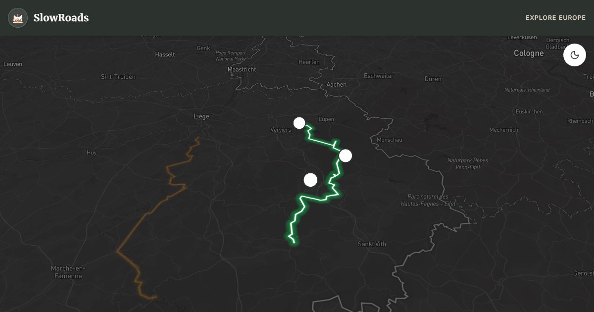
Limbourg to Vielsalm via Eupen and the High Fens (Botrange 694 m) — Belgium's wildest plateau of blanket bog and heath. Sustained 8–10% climbs demand cooling stops in classic and low-power vans; fuel in Eupen before the reserve. Mist, purple heather and Malmedy–Stavelot history frame the day; stick to marked fen boardwalks and never drive off-road onto peat. Best as a careful half-day to full day with cooling breaks — not a rush between Limbourg and Vielsalm. Overnight at valley campsites after the plateau.
Detailed Route Guide
The Eastern Ardennes and High Fens route explores the wildest, highest, and most remote corner of Belgium — a landscape that feels more Nordic than Central European. The route begins in historic Limbourg, a perfectly preserved fortified town perched on a rocky promontory above the Vesdre river. Though just minutes from Liège's industrial suburbs, Limbourg feels centuries removed, its cobbled streets and Gothic church creating a dramatic prelude to the wilderness ahead. From here the route climbs to the German-speaking east, passing through Eupen — Belgium's only German-speaking city and a charming place largely unknown to other tourists.
The centrepiece of this route is the Hautes-Fagnes (High Fens), a vast, elevated plateau of blanket bog and heathland that feels genuinely alien in a densely populated country like Belgium. Botrange, at 694 metres, is the highest point in the country, and the area is a strict nature reserve where access is restricted to marked paths. The atmosphere here is unforgettable: on clear days the views stretch to the Eifel hills in Germany; on misty days the peat hags and dwarfed pine trees disappear into a grey void. The Signal de Botrange visitor centre provides excellent context on this unique ecosystem. Descending south, the route passes through Malmedy — scene of the SS massacre of American POWs in December 1944 — and the grand Benedictine abbey of Stavelot, home to an extraordinary carnival museum and Trappist beer heritage.
For classic and low-power campervans, honest advice is needed here. This is the most challenging Belgian route for a low-powered vehicle. The approach to the High Fens plateau involves sustained climbs of 8–10% over several kilometres. A well-maintained classic or low-power campervan with a competent driver will manage, but monitor your engine temperature carefully, use a lower gear on the ascents, and allow the engine to rest at the summit before descending. The rewards are immense, but this is not a route for a classic camper with known cooling or mechanical issues. Fuel up in Eupen before heading into the nature reserve — there are very few stations in the high zone.
Season matters greatly on this route. The High Fens are at their most dramatic in late autumn when the heather is brown and mist hangs low, and in winter when snow can make the plateau a white wilderness. Summer brings the most accessible conditions. Spring is magical when the heather blooms purple. Note that the plateau roads can be slippery in frost, and some minor tracks into the reserve may be officially closed in winter to protect the bog ecosystem.
Before the High Fens climb, check coolant and oil, and do not switch off a hot engine at Botrange — idle to cool. Overnight in Eupen, Malmedy or Vielsalm campsites; the reserve itself has no camper overnighting. Winter frost on plateau roads is common — if ice is forecast, keep to lower valley alternatives around Stavelot.
Limbourg's walls and Eupen's German-speaking streets bookend the climb onto the fen plateau. Signal de Botrange explains the bog; Malmedy and Stavelot bring abbey and wartime memory back into the valleys. Spa-Francorchamps sits just off-route for motorsport fans on non-race days. Treat the High Fens as the serious half of the day and the abbey towns as the recovery.
Frequently Asked Questions
Points of Interest
Botrange (Highest Point)
Nature
Limbourg Old Town
Town
Spa-Francorchamps Circuit
Monument
Route Highlights
Route Information
Navigation
* Supported by HERE Technologies, headquartered in Amsterdam, Europe. Precise routing through all waypoints.
* Waze only navigates to the starting point. Use Google Maps for the full scenic route.
Offline GPS Navigation
Download the GPX route file to navigate offline using your favorite GPS device or app (Garmin, TomTom, OsmAnd, Gaia GPS).
Ask Copilot (AI Travel Guide)
Hello! I am your SlowRoads Copilot. I know the Eastern Ardennes & High Fens intimately. Ask me about scenic viewpoints, local history, hidden culinary gems, or the best camper spots along the way!