About This Route
Luxembourg's sandstone wonderland — Echternach abbey town, Schiessentümpel waterfall, and forest loops through the Mullerthal trail network of beech gorges and rock formations. Gentle grades on narrow lanes suit classic and low-power campervans if you yield at pullouts and park outside Echternach's core. Walk the trails; the van stays on asphalt. Pair with Moselle wine days for a compact Benelux contrast of gorge shade and riverside terraces. Spring wildflowers and autumn colour are peak; summer weekends bring hikers. Slow, green, and close to three borders.
Detailed Route Guide
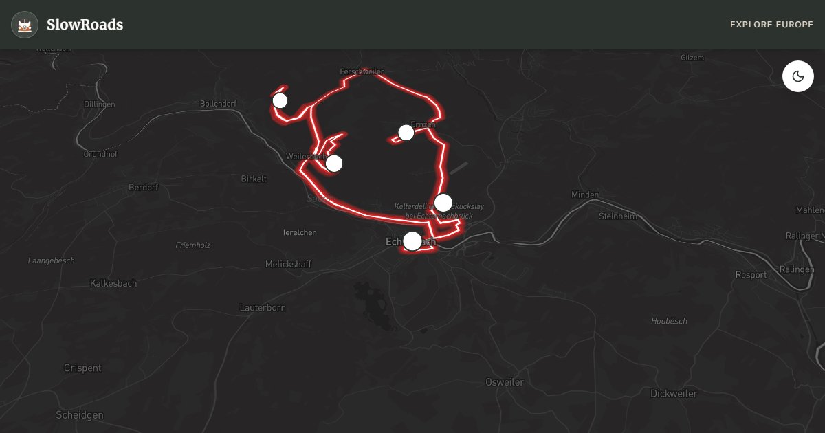
Müllerthal — Luxembourg's "Little Switzerland" — is a compact sandstone landscape where beech forests fold into narrow gorges, waterfalls tumble over mossy ledges, and a 112-kilometre marked trail network connects abbey towns, rock pillars, and stream valleys in one of the Benelux's most rewarding slow-travel regions. This roughly 28-kilometre driving loop centred on Echternach accesses the trail system's highlights by van: park at designated lots, hike sections of the Mullerthal Trail, and return to forest lanes with grades gentle enough for any air-cooled engine.
Echternach anchors the loop — Luxembourg's oldest town with a Benedictine abbey whose Whit Tuesday dancing procession draws thousands in spring. The abbey square, Roman walls, and riverside park make a contemplative start; van parking at the municipal lot south of the centre avoids the old town's tight lanes. From Echternach, CR121 and forest roads thread north into the Mullerthal proper — lanes narrow to single-track in places but remain paved, with occasional 5% grades through beech woodland.
Schiessentümpel waterfall is the signature stop — a cascade where the Black Ernz river drops over a sandstone shelf into a pool, surrounded by ferns and the peculiar rock formations that define the region. Parking is a five-minute walk from the falls; arrive before 10 AM in summer for solitude. Berdorf, nearby, offers rock pillar viewpoints and the Wolfsschlucht gorge trail with ladders through narrows — hiking-only but accessible from roadside trailheads.
For classic and low-power campervan drivers, Müllerthal is ideal Benelux mountain scenery without Alpine stress — maximum grades around 5%, excellent surfaces, and Wohnmobil-Stellplätze in Echternach and Berdorf. The region pairs naturally with Germany's Mosel Wine Road (about 45–60 minutes toward Trier) for a cross-border wine-and-forest week. Visit April through October; spring wildflowers and autumn beech colour are peak. Winter trails are muddy but drivable. Müllerthal rewards a classic campervan that parks and walks: Schiessentümpel and Wolfsschlucht are short hikes from lots, not drive-through spectacles. Stellplatz Echternach on the Sûre covers overnighting; old-town lanes are too tight for loaded vans. Grades top out near 5% on paved CR roads with occasional single-track — pass carefully. Link west toward Germany's Mosel Wine Road (about 45–60 minutes to Trier) for a forest-and-wine Benelux–Germany week. Echternach's Whit Tuesday dancing procession draws spring crowds — plan parking south of the abbey square and walk in. Berdorf rock pillars and climbing viewpoints sit a short forest drive from the waterfall; trailheads are signed from CR lanes. The 112-kilometre Mullerthal Trail network is the region's soul — even one 45-minute gorge walk transforms the driving loop from pretty lanes into Little Switzerland. April–June wildflowers and September–October beech colour are peak; summer weekends pack popular trailheads. Carry euro coins for parking meters and treat single-track forest bends with courtesy mirrors.
Start early for Schiessentümpel solitude, then spend the afternoon on a Berdorf or Wolfsschlucht section before returning to Echternach's riverside Stellplatz. That simple rhythm — park, walk, taste a forest café, sleep legal — is Müllerthal at van pace, and it never requires more horsepower than courtesy and cool brakes on the short descents.
Frequently Asked Questions
Points of Interest
Echternach Abbey
Monument
A Benedictine abbey with dancing procession tradition — Luxembourg's spiritual heart.
Schiessentümpel Waterfall
Nature
A mossy cascade over sandstone ledges — the Mullerthal's most photographed spot.
Wolfsschlucht Gorge
Nature
A narrow sandstone gorge on the Mullerthal trail — ladders and rock passages.
Berdorf Rock Formations
Nature
Sandstone pillars and caves above the Sûre valley — climbing and viewpoint trails.
Mullerthal Trail Hub
Town
Marked trail network centre with parking and forest café stops.
Route Highlights
Route Information
Navigation
* Supported by HERE Technologies, headquartered in Amsterdam, Europe. Precise routing through all waypoints.
* Waze only navigates to the starting point. Use Google Maps for the full scenic route.
Offline GPS Navigation
Download the GPX route file to navigate offline using your favorite GPS device or app (Garmin, TomTom, OsmAnd, Gaia GPS).
Ask Copilot (AI Travel Guide)
Hello! I am your SlowRoads Copilot. I know the Müllerthal Little Switzerland intimately. Ask me about scenic viewpoints, local history, hidden culinary gems, or the best camper spots along the way!