About This Route
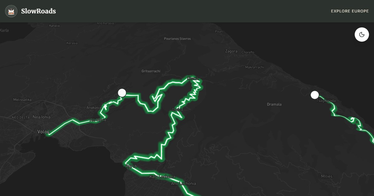
Climb Mount Pelion from Volos toward Tsagarada — about 92 km of chestnut-forest hairpins linking stone villages to Aegean pebble beaches. Steep grades demand sound cooling and low gears in classic and low-power campervans; engine-brake on descents to Mylopotamos. Portaria trails, Tsagarada’s ancient plane tree, and green hillsides reward patient stops. Organised campsites only. April–June and September–October beat July heat on the climb. Winter can close higher lanes with snow. Fill fuel in Volos before the ridge; leave large vans outside the tightest village plateias and walk in.
Detailed Route Guide
Mount Pelion occupies a singular place in Greek mythology: it was the home of the Centaurs, the half-man half-horse creatures tutored by the wise Chiron, who educated heroes like Achilles and Jason here among the chestnut trees and mountain streams. The landscape lives up to its mythic reputation. The peninsula curves around the Gulf of Volos like a great green arm, its spine of forested mountains dropping sharply on the eastern side to hidden Aegean beaches that feel a world away from the dry, sunbaked plains of the Greek interior. This is "mountain meets sea" in its most spectacular form: apple and chestnut orchards at 600 metres elevation give way, just a few steep kilometres below, to turquoise coves accessible only by boat or on foot — or, for the truly committed, by an extremely winding road.
Driving from the port city of Volos into the mountains, you almost immediately feel the altitude and the cool shade of the forest canopy. The road climbs through Portaria, one of the most beautifully preserved of the traditional Pelian villages — stone-paved streets, slate-roofed houses, and a central plane tree casting shade over a small plateia. Higher still, Makrinitsa (a short detour but highly recommended) clings to the mountainside with spectacular views down to Volos and the Pagasetic Gulf. The drive then descends dramatically toward the Aegean coast, where Agios Ioannis and Mylopotamos beach offer some of the most striking swimming spots in mainland Greece — pebble and sand coves framed by vertical green hillsides. Tsagarada, the endpoint, is famous for its extraordinary plane tree: over 1,000 years old, with a hollow trunk so large that multiple people can stand inside it.
For classic and low-power campervans, the Pelion loop represents one of the most demanding drives in this entire guide — not because of road quality, which is generally good, but because of the extreme frequency and tightness of the bends. The road is essentially a constant series of hairpin turns from Volos to the coast, with gradients regularly touching 10–12% on certain sections. A naturally aspirated diesel or petrol engine in an older camper will be working hard on the climbs, and the brakes will be working equally hard on the descents. Tackling this route requires a thoroughly well-maintained vehicle. Do the climbs in the cool of the morning, carry plenty of water for the radiator, and use engine braking generously on the way down. The payoff is immense: at the top, air that smells of chestnut and pine; at the bottom, water so clear it looks artificial.
The Pelion is at its best from April to June and from September to October. In spring, the apple trees blossom, the streams run full, and the whole mountain smells of wildflowers. Summer is hot but the altitude moderates temperatures on the upper slopes, and the Aegean beaches on the eastern coast provide relief. The Pelion is popular with Greek domestic tourists in August, so the mountain villages and the better-known beaches (Mylopotamos, Agios Ioannis) get crowded — arrive early at any beach if driving in summer. Autumn brings mushroom-picking season, falling chestnuts, and extraordinary amber light filtering through the forest canopy.
Frequently Asked Questions
Points of Interest
Centaur's Path (Portaria)
Nature
Forest trail above Portaria's stone plateia
Mylopotamos Beach
Nature
Turquoise pebble cove below steep green hillsides
Historic Tsagarada Plane Tree
Nature
Thousand-year-old plane tree with a hollow trunk
Route Highlights
Route Information
Navigation
* Supported by HERE Technologies, headquartered in Amsterdam, Europe. Precise routing through all waypoints.
* Waze only navigates to the starting point. Use Google Maps for the full scenic route.
Offline GPS Navigation
Download the GPX route file to navigate offline using your favorite GPS device or app (Garmin, TomTom, OsmAnd, Gaia GPS).
Ask Copilot (AI Travel Guide)
Hello! I am your SlowRoads Copilot. I know the Pelion Peninsula Loop intimately. Ask me about scenic viewpoints, local history, hidden culinary gems, or the best camper spots along the way!