About This Route
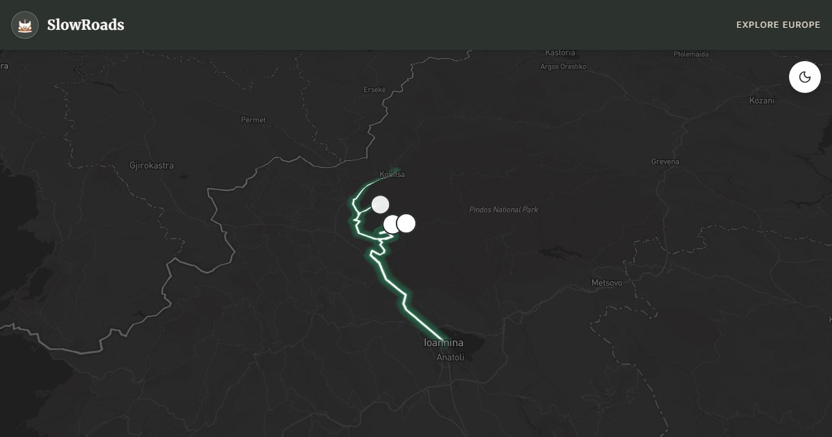
Cross Zagori from Ioannina toward Konitsa — stone villages, arched bridges, and Vikos Gorge viewpoints on mountain secondary roads for patient classic campervans. Expect narrow lanes, short steep climbs, and polished wet asphalt; low-power vans need sound brakes, cooling, and frequent pull-outs. Park outside village cores and walk to viewpoints. Organised campsites and guesthouse parking only — wild camping in the national park is illegal. May–June and September suit gorge light; winter snow can close higher approaches. Fill fuel in Ioannina before quieter highland stretches. A slow two-day pace beats rushing the bridges in one afternoon.
Detailed Route Guide
Eighty-five kilometres from Ioannina to Konitsa traverse the Zagori region of Epirus — a landscape of stone villages (Zagorochoria), arched bridges spanning turquoise rivers, and the Vikos Gorge, a dramatic limestone canyon often cited among Europe's deepest relative to its width. The driving is steep and continuous: switchbacks climb from Ioannina's lake basin through Vikos-Aoos National Park toward Monodendri, Papingo, and the Vikos viewpoint at Oxia, where the gorge drops 900 metres to the Voidomatis river below. For a classic or low-power campervan, this route demands second gear, engine braking, and coolant vigilance on long climbs — especially fully loaded vans heading toward the Papingo twin villages at over 900 metres elevation.
Ioannina opens the journey on the shores of Lake Pamvotis, where Ottoman-era mosques and a fortress island (Nissaki) reward a morning walk before entering the mountains. Monodendri and the smaller Zagori villages preserve stone mansions built by eighteenth-century merchants who traded across the Balkans — walking the cobbled kalderimi paths between villages is as essential as driving the connecting roads. The Vikos Gorge viewpoint at Oxia delivers the route's defining panorama; arrive early before coach groups fill the small car park. Konitsa at the northern end sits above the Aoos river with the single-arched Konitsa bridge — a slender stone span where locals still pose for wedding photographs — and access toward the Pindos mountains and Albania border crossings.
Stone bridges punctuate the route: the three-arched Plakidas (Kalogeriko) bridge near Kipi, the Noutsou bridge at Koukouli, and the Konitsa bridge itself — each built without mortar in the eighteenth and nineteenth centuries and now protected heritage sites. Papingo's Mikro and Megalo villages offer trout tavernas and base camps for Vikos hikes; snow can linger on surrounding peaks into May, and morning mist in the gorge bottom makes the Voidomatis river look like smoked glass from the Oxia rim.
Campervan parking is limited inside village cores — use municipal lots at Monodendri and Konitsa rather than attempting stone lanes built for mule traffic. Campgrounds exist near Aristi and Konitsa with flat pitches suited to older campervan levelling. Fuel in Ioannina and Konitsa; grocery resupply before ascending to Papingo where shops are seasonal. May and June bring green gorges and wildflowers; September offers crisp air and empty viewpoints. Winter closes some mountain passes with snow — chains recommended December through March. Two days minimum: Ioannina and Monodendri day one, Vikos viewpoints and Konitsa day two.
Practical notes for low-power campervans: climbs from the Ioannina basin toward Monodendri and Papingo are sustained enough that morning starts matter in summer heat. Carry extra coolant water, use second gear early, and engine-brake on the return descents. Village cores are built for mule traffic — leave the van in municipal lots and walk the kalderimi paths. The Oxia viewpoint car park fills with coaches by late morning; arrive early or accept a short walk from overflow parking. Snow and ice can close higher Zagorochoria lanes from December into March; chains are wise if you travel then. Organised camping near Aristi or Konitsa is safer than informal overnighting inside the national park. Pair Zagori with a lake day in Ioannina or a continuation toward Konitsa and the Aoos if you want a three-day Epirus slow loop.
Frequently Asked Questions
Points of Interest
Vikos Gorge Viewpoint
Nature
Deep limestone gorge above the Voidomatis
Kokkori Bridge
Monument
Arched stone bridge
Monodendri
Town
Gateway village to Vikos
Route Highlights
Route Information
Navigation
* Supported by HERE Technologies, headquartered in Amsterdam, Europe. Precise routing through all waypoints.
* Waze only navigates to the starting point. Use Google Maps for the full scenic route.
Offline GPS Navigation
Download the GPX route file to navigate offline using your favorite GPS device or app (Garmin, TomTom, OsmAnd, Gaia GPS).
Ask Copilot (AI Travel Guide)
Hello! I am your SlowRoads Copilot. I know the Zagori & Vikos Gorge Drive intimately. Ask me about scenic viewpoints, local history, hidden culinary gems, or the best camper spots along the way!