About This Route
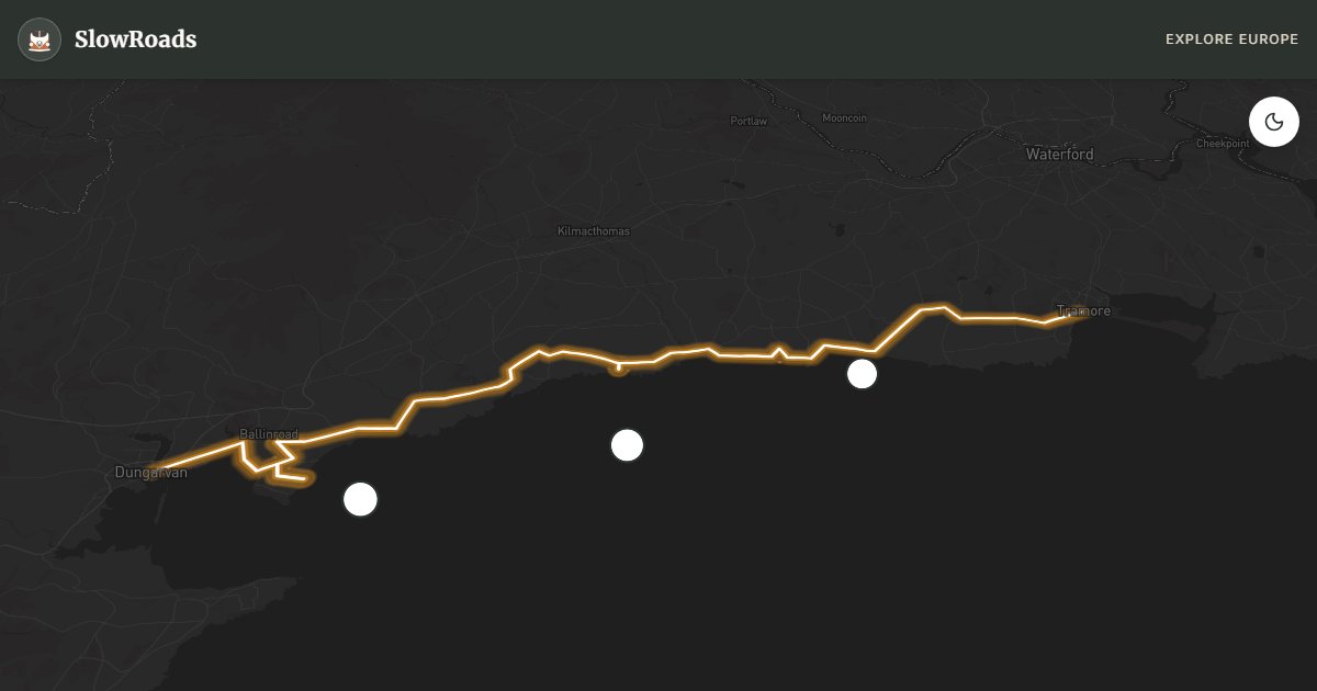
Cruise Waterford’s Copper Coast UNESCO Geopark from Tramore to Dungarvan — about 43 km on the gentle R675 for classic campervans. Volcanic cliffs, Bunmahon mining heritage, Tankardstown engine-house ruins, and sea stacks reward unhurried stops without alpine grades. Left-hand traffic; official campsites only — no wild-camping right. One easy day suits older low-power vans; linger for geology walks and quieter coves off peak weekends. Fill fuel in Tramore or Dungarvan. May–September offer the best light; winter storms make cliff pull-offs dramatic but exposed. A calm southeast contrast to Kerry’s coach-heavy loops.
Detailed Route Guide
Fifty kilometres from Tramore to Dungarvan trace Waterford's Copper Coast — a UNESCO Global Geopark where ancient volcanic rocks meet the Celtic Sea in sea stacks, rhyolite cliffs and beaches most Ireland itineraries skip. The R675 follows the coast through former copper-mining villages where nineteenth-century engine houses still stand beside surf breaks. Driving is gentle for classic and low-power campervans: rolling farmland, cliff-top stretches with wide sightlines, and no mountain passes to overheat a modest engine. One full day covers the geopark comfortably if you start early and treat each stop as a destination.
Tramore opens with Victorian seaside atmosphere — a long beach backed by cliffs, the Metal Man navigation beacon guiding ships since 1823, and a promenade car park useful as a staging point before heading west. Bunmahon sits in a sheltered bay where copper was mined from the 1820s until the industry collapsed in the 1880s — rust-stained spoil contrasts with pale sand, and Geopark trails explain basalt dykes and rhyolite that draw geologists. Tankardstown engine-house ruins crown a headland above sea stacks; arrive before midday for clifftop parking and walk the copper-trail boards mapping industrial archaeology below.
The Geopark Visitor Centre at Bunmahon offers interpretation, tide tables and guided-walk schedules — worth thirty minutes before cliff paths that slick after rain. Dungarvan at the end is a harbour town where the Waterford Greenway begins its long off-road cycle path, with harbour parking near pubs serving Atlantic fish and local blaas bread. Campervan parking works at Tramore promenade (check overnight signage — rules vary by season), Bunmahon beach car park and Dungarvan harbour. These are not wilderness wild-camping spots; wild camping is not a legal right in Ireland — use signed areas and campsites.
May carpets cliff paths with wildflowers and keeps lots quieter before summer family traffic. August can warm Bunmahon enough for a swim on calm days — midweek avoids weekend crowds from Cork and Dublin. Winter storms strip sand and expose mining debris along the shore — dramatic photos, but some cliff paths close in high wind. One day is the realistic minimum for Tramore, Bunmahon, Tankardstown and Dungarvan; add a half-day for the Tramore cliff walk and a slow lunch watching rollers hit the stacks.
The Copper Coast is the antidote to Kerry coach traffic: short distances, empty cliff paths on weekdays, and geology you can read from the roadside without a mountain pass. Use it as a recovery day between ferry arrival at Rosslare or Cork and the bigger Wild Atlantic loops, or as a finale when you want Atlantic drama without narrow peninsula stress. Classic campervans fit standard bays in Tramore and Dungarvan more easily than on Slea Head. Tide timing matters for beach walks at Bunmahon — check tables at the visitor centre before committing to foreshore paths. After rain, clay on cliff trails turns slick; waterproof boots beat fashion shoes. Pair the drive with a Greenway cycle from Dungarvan if you carry bikes, or simply sit above the stacks with a flask and watch the Celtic Sea work the volcanic rock. That unhurried hour is the point of the route.
Frequently Asked Questions
Points of Interest
Bunmahon Beach
Nature
Copper mining heritage beach
Tankardstown
Nature
Engine house ruins and sea stacks
Geopark Visitor Centre
Monument
UNESCO Global Geopark interpretation
Route Highlights
Route Information
Navigation
* Supported by HERE Technologies, headquartered in Amsterdam, Europe. Precise routing through all waypoints.
* Waze only navigates to the starting point. Use Google Maps for the full scenic route.
Offline GPS Navigation
Download the GPX route file to navigate offline using your favorite GPS device or app (Garmin, TomTom, OsmAnd, Gaia GPS).
Ask Copilot (AI Travel Guide)
Hello! I am your SlowRoads Copilot. I know the Copper Coast UNESCO Drive intimately. Ask me about scenic viewpoints, local history, hidden culinary gems, or the best camper spots along the way!