About This Route
Drive Road 387 — Droga Stu Zakrętów — from Kudowa-Zdrój to Radków through Stołowe National Park — about 47 km of sandstone hairpins for patient low-power campers. Shaded bends stay cool and can hold damp; use low gears and engine braking. Park in Karłów for Szczeliniec Wielki hikes; leave the van off the tightest forest edges. Campsites in spa towns only — no overnighting on park lay-bys. May–June and September beat summer coach peaks; winter ice demands serious tyres. Fill fuel in Kudowa before the climbs. Classic-camper patience matches this short, intense Table Mountains ribbon.
Detailed Route Guide
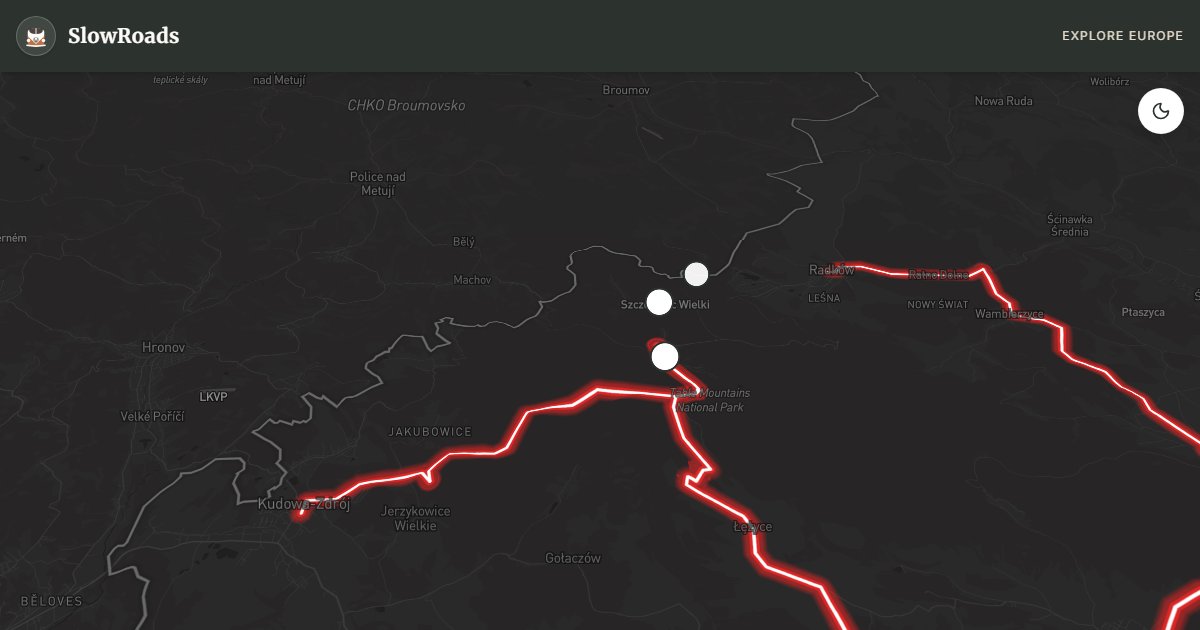
Droga Stu Zakrętów — the Road of a Hundred Turns — is Voivodeship Road 387, one of Poland's most famous mountain drives. About 47 kilometres link the spa town of Kudowa-Zdrój with historic Radków, climbing into Stołowe Mountains (Table Mountains) National Park near the Czech border. Built in the late nineteenth century under Prussian rule, the road is cut into sandstone cliffs with retaining walls of local red stone above wooded gorges. The name is fair: a continuous ribbon of bends, switchbacks, and hairpins through pine and beech forest that rewards slow steering more than speed.
The landscape is unusual for Poland. Stołowe are plated mountains — flat sandstone layers eroded into labyrinths, mushroom rocks, and deep crevasses. Mid-route Karłów is the trailhead for Szczeliniec Wielki (919 m), the range high point: hundreds of stone steps lead into a rock maze and viewing platforms over the forest plateau. Nearby Błędne Skały (Errant Rocks) is another natural maze and a known film location. On the descent toward Radków, Radkowskie Skały rise as vertical sandstone columns beside the carriageway, crowns of pine on top — dramatic from the van window if you keep speeds low enough to look.
For older and low-power campervans this is a steering, braking, and patience test rather than a long alpine pass. The climb from Kudowa starts at once toward the Karłów plateau; gradients reach about 8–10%, so drop early into second gear and watch coolant temperatures on warm days. The road is narrow, tree-shaded, and edged by rock faces with limited passing places. The Radków descent is tighter still — use engine braking, keep brakes cool, and never rush blind hairpins where oncoming traffic or cyclists appear late. Length is short, but allow half a day with photo and hike stops; do not treat it as a quick transit between spa towns.
Wild camping is prohibited inside the national park. Use campsites and camper-friendly stays in Kudowa-Zdrój and Radków, then day-drive the bends. The road is open year-round, yet winter is serious: shade holds ice long after main highways clear, so winter tyres are essential and chains help loaded campers after storms. May–June and September offer the best balance of open trails, colour, and lighter traffic. July–August bring hikers to Karłów and more cars on the bends. Pair the drive with a hike — the sandstone labyrinths are why the park exists — and consider a cross-border day into Czech Adršpach–Teplice rock towns from Kudowa if you have extra time.
Fuel and simple supplies are easiest in Kudowa-Zdrój before you climb; Radków has cafés after the descent. If your camper is long or high, take the hairpins wider and yield early — some bends feel single-track when two vehicles meet. Cyclists and tour buses share the road in summer, so expect sudden slowdowns. After rain, sandstone grit on the surface can be slippery even when the gradient looks modest. Treat the Hundred Turns as a scenic half-day with a hike, not a shortcut across the border hills.
Frequently Asked Questions
Points of Interest
Szczeliniec Wielki
Nature
Highest peak of Stołowe Mountains National Park, featuring a labyrinth of giant sandstone rocks.
Radkowskie Skały
Nature
Dramatic vertical sandstone columns rising right next to the forest road.
Karłów Village
Town
Charming settlement at the foot of Szczeliniec Wielki, the perfect starting point for hiking.
Route Highlights
Route Information
Navigation
* Supported by HERE Technologies, headquartered in Amsterdam, Europe. Precise routing through all waypoints.
* Waze only navigates to the starting point. Use Google Maps for the full scenic route.
Offline GPS Navigation
Download the GPX route file to navigate offline using your favorite GPS device or app (Garmin, TomTom, OsmAnd, Gaia GPS).
Ask Copilot (AI Travel Guide)
Hello! I am your SlowRoads Copilot. I know the The Road of a Hundred Turns intimately. Ask me about scenic viewpoints, local history, hidden culinary gems, or the best camper spots along the way!