About This Route
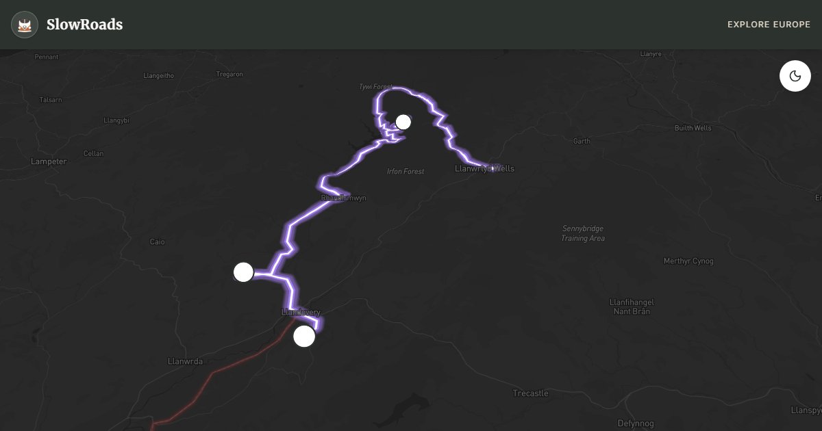
The quiet A483 Heart of Wales hills from Llanwrtyd Wells to Llandovery suit classic and low-power campervans seeking empty mid-Wales sheep country. About 60 km of light traffic and modest grades mirror the spirit of the scenic Heart of Wales railway — chapels on ridges, long sight lines, and red kites overhead. Fill fuel before you leave town; services are sparse between stops. Optional northward detour via Builth Wells and the A470 reaches Gigrin Farm near Rhayader for once-daily red-kite feeding (confirm times and book ahead). Near Llandovery, Cwm Rhaeadr waterfall rewards a short west spur. Wild camping without landowner permission is generally illegal — use farm pitches, not A483 lay-bys. One full day, or add a half-day for the kite spectacle.
Detailed Route Guide
The Heart of Wales Line Road follows the spirit of one of Britain’s most scenic railways along the A483 through empty Cambrian hill country between Llanwrtyd Wells and Llandovery — about fifty-five kilometres where sheep outnumber cars and red kites often wheel above oak valleys. This is mid-Wales at its most unhurried: market towns spaced far apart, chapels on ridges, and pastoral farming rather than mass tourism. A classic or low-power campervan can cover the distance in a morning, but the point is a full day with wildlife stops and a pub lunch that stretches into the afternoon.
Llanwrtyd Wells — often billed as Britain’s smallest town and known for eccentric events such as bog snorkelling — makes a memorable start. South on the A483, rolling sheep pasture and long sight lines replace mountain drama; traffic is light. Fuel and food are sparse between towns — fill up in Llanwrtyd Wells or Llandovery and carry lunch. Near Llandovery, a short west detour reaches Cwm Rhaeadr, a wooded waterfall on the slopes of Mynydd Mallaen that most through-traffic never sees.
Gigrin Farm’s celebrated red-kite feeding station is not on the direct A483 between Llanwrtyd Wells and Llandovery — it sits near Rhayader, a worthwhile northward detour via Builth Wells and the A470 if you want the afternoon spectacle. Feeding is once daily (typically 3pm in British Summer Time season, 2pm after the clocks change in late October — confirm on gigrin.co.uk and book ahead). Hundreds of kites can descend to the hillside platform; allow an hour with binoculars. Llandovery closes the core route with Norman castle ruins above the Tywi, a market square and the sense of reaching the southern edge of strongly Welsh-speaking country.
The A483 is ideal low-power territory: generally well surfaced, without the double-digit gradients of the high passes. Overnight at farm campsites or sites that explicitly allow motorhomes around Llanwrtyd Wells, Rhayader (if you detour) or Llandovery — roadside lay-by overnighting is discouraged, and wild camping without landowner permission is generally illegal. Autumn light on the hills pairs well with kite watching; spring brings lambs and courtship displays. After cold nights, check ice on the minor road to Cwm Rhaeadr. Pair this gentle day with the steeper A4069 Black Mountain Pass from Llandovery if you want contrast. Think of this A483 day as the antidote to celebrity mountain roads: few coaches, honest gradients, and time to watch weather move across Cambrian ridges. If you add Gigrin Farm, leave Llanwrtyd Wells early enough to reach Rhayader before the farm opens for the afternoon feeding — numbers are limited and booking is recommended. Bring binoculars; rare leucistic (pale) kites sometimes appear among the hundreds. Back on the core Llanwrtyd–Llandovery leg, expect agricultural traffic and the occasional slow tractor rather than sports cars. Llandovery’s castle ruins and independent shops make a natural overnight before tackling the A4069 Black Mountain Pass southbound. Classic and low-power campervans should still carry spare coolant and a torch for early or late arrivals at farm gates. Mid-Wales rewards those who treat fifty-five kilometres as a full day of looking up.
Frequently Asked Questions
Points of Interest
Red Kite Feeding Station
Nature
Gigrin Farm near Rhayader — detour north of the A483
Cwm Rhaeadr Waterfall
Nature
Wooded waterfall near Mynydd Mallaen
Llandovery Castle
Castle
Norman castle ruins above the Tywi
Route Highlights
Route Information
Navigation
* Supported by HERE Technologies, headquartered in Amsterdam, Europe. Precise routing through all waypoints.
* Waze only navigates to the starting point. Use Google Maps for the full scenic route.
Offline GPS Navigation
Download the GPX route file to navigate offline using your favorite GPS device or app (Garmin, TomTom, OsmAnd, Gaia GPS).